Property Information Report

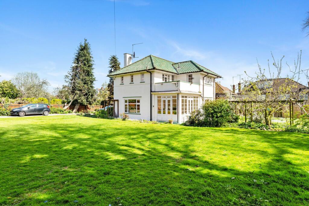
Four Winds, Quakers Walk
London, N21 2DE
Key Facts
No lease data available
About Us

About Us
Since 2006 we’ve committed ourselves to helping people move happy. We do so with a promise to support the local community too. We feel estate agency can and should be done differently; in a professional and yet personal way. Everything we do is designed around you and our team of property experts all have one thing in common – they care.
Find out more at locationlocation.com
Generate a full report on your own property including an instant estimated valuation.
Title Plan
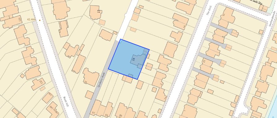 Contains OS data © Crown copyright 2025
Title Information
Details provided by the Land Registry
- Title Number
- MX19273
- Plot Size
- 0.25 acres (1003 sq metres)
Street View
House Prices in Enfield
Last 12 months
-
Average Price Change
£16,193
Increased by 4%
-
Detached Price Change
£58,033
Increased by 5%
Average House Prices
Last 12 months for all property types.
Since - May 2020
-
Average Price Change
£53,473
Increased by 13%
-
Detached Price Change
£159,757
Increased by 15%
Average House Prices
Since 2020 for all property types
EPC
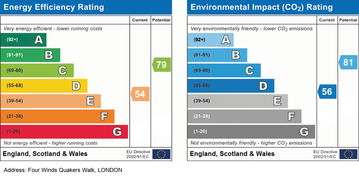
EPC Information
Details taken from the EPC register
- Date
- 2025-01-08
- Valid Until
- 2035-01-07
- Energy Efficiency - Current
- 63
- Energy Efficiency - Potential
- 84
- Environmental Impact - Current
- 53
- Environmental Impact - Potential
- 79
Recently Sold Properties in the Area
| Address | Property Type | Distance | Price | Completed |
|---|---|---|---|---|
|
77 Bush Hill Road London, N21 2DP |
Semi-Detached | 0.11 km away | £700,000 | 10 months ago |
|
124 Bush Hill London, N21 2BS |
Semi-Detached | 0.11 km away | £905,000 | 6 months ago |
|
33 Bush Hill London, N21 2BT |
Semi-Detached | 0.19 km away | £1,920,000 | 10 months ago |
|
34 Borden Avenue Enfield, EN1 2BY |
Terraced | 0.28 km away | £785,000 | 8 months ago |
|
14 Sittingbourne Avenue Enfield, EN1 2DA |
Terraced | 0.28 km away | £453,000 | 7 months ago |
|
21 Bush Hill Road London, N21 2DP |
Semi-Detached | 0.30 km away | £572,000 | 9 months ago |
|
24 Borden Avenue Enfield, EN1 2BZ |
Terraced | 0.33 km away | £680,000 | 5 months ago |
|
3 Ringmer Place London, N21 2DD |
Detached | 0.35 km away | £1,400,000 | 9 months ago |
|
7 Park Drive London, N21 2LU |
Semi-Detached | 0.40 km away | £935,000 | 4 months ago |
|
22 Berkeley Gardens London, N21 2BA |
Terraced | 0.41 km away | £650,000 | 6 months ago |
Schools
| Name | Type | Postcode | Distance | Rating |
|---|---|---|---|---|
| Grange Park Preparatory School | Independent, Nursery, Primary | N21 2EA | 0.72 km | Not rated |
| Edmonton County School | All through | N9 9JZ | 0.93 km | Good |
| Raglan Infant School | Nursery, Primary | EN1 2NS | 0.97 km | Good |
| The Raglan Junior School | Primary | EN1 2RG | 0.98 km | Good |
| St Paul's CofE Primary School | Primary | N21 2RA | 1.20 km | Good |
Transport
Bus Stops & Stations
Details provided by Department for Transport
| Name | Distance |
|---|---|
| Conifer Gardens | 0.39 km |
| St. Stephens Church, PARK AVENUE | 0.42 km |
| Bush Hill Road | 0.46 km |
| Church Street | 0.48 km |
| Bush Hill, PARK AVENUE | 0.49 km |
Train Stations
Details provided by Department for Transport
| Name | Distance |
|---|---|
| Grange Park Station | 0.81 km |
| Grange Park Rail Station | 0.87 km |
| Bush Hill Park Rail Station | 1.11 km |
| Bush Hill Park Station | 1.12 km |
| Winchmore Hill Rail Station | 1.31 km |
Nearest Motorway
Details provided by Department for Transport
| Name | Distance |
|---|---|
| M25 | 5.30 km |
Coverage
- Average Broadband Speed:
-
17mb Basic
-
17mb Overall
- Mobile Coverage:
-
EEOkay
-
O2Good
-
ThreeOkay
-
VodafoneOkay

Location Location, 18 Stoke Newington Church Street, London, N16 0LU
Selling with Location Location
Important Notice - This report is intended for general informational purposes only and should act only as a guide. The report is produced automatically on behalf of Location Location - Location Location Hackney by Street Insights, a product of Street Systems Ltd. Street Systems maintains and aggregates data from multiple public data sources and whilst every effort is made to keep information up to date and accurate, we make no representations or warranties of any kind about the accuracy, reliability or completeness of the information contained within this report for any purpose. Any reliance you place on the data contained within this report is strictly at your own risk. In no event will Location Location - Location Location Hackney or Street Systems Ltd be liable for any loss or damage including without limitation, indirect or consequential loss or damage, or any loss or damage whatsoever arising from loss of data or profits arising out of, or in connection with, the use of this report.
This report contains public sector information licensed under the Open Government License v3.0
Transaction data and HPI data is produced by HM Land Registry. Crown copyright and database rights 2025